Posts

Showing posts with the label Hurricane Irene

Wells Memorial Library

I'm passing this on from Vermont College of Fine Arts regarding author Kate Messner, who started a drive to help a tiny library in a poor area. ** I'd gone with my meteorologist husband to take photographs of flood damage in Essex County, just to our south. Roads were washed out, bridges closed or in pieces, familiar sights to anyone who's seen news coverage coming out of Vermont this week. But these tiny towns along Adirondack rivers haven't gotten much media attention. "Go on up ahead," one town supervisor told us from his pickup. "You need to see Upper Jay. It's awful." We made our way through roads that were down to one lane, and took detours when there was no road. As we drove around a bend in the road today, my husband slowed down. "Whoa…look at all the stuff in front of that house." But it wasn't a house. It was the library. They lost virtually their entire children's collection. All of the picture books...
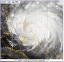
Into the Eye of the Hurricane

Image
Accordng to Tom Skilling, WGN's TOP meterologist: Here's Irene--645 mi south of Cape Hatteras with 115 mph sustained winds churning north/northwest at 13 mph. It's at lat 25.9N long 76.8W and has a central pressure of 951 mb (28.08"). It is generating 12 ft or greater ocean swells out 345 mi from its center and its tropical storm force (39+ mph) winds reach up to 290 mi from its center and hurricane force winds (74+ mph) extend out to 70 mi from the eye. Hurricane watches have been posted from Surf City NC to the NC/VA border & tropical storm watches are out for Edisto Beach SC north to Surf City NC.  We just said goodbye to Grace who is heading into the eye of the hurricane. Not only do I have to worry about sending my only child off to college, to live in NYC, where she doesn't yet have an apartment and school starts in 3 days--that is if school starts on Monday, but now on top of all this I have Hurricane Irene to worry about.  Good luck New York Ci...